FINALLY! We started up our waterfalling tour after a much too long hiatus! What better way to start the new season than attending the second most fascinating waterfalls in Ontario next to Niagara Falls!!!!
It wasn't until we reached this destination did we realize that the waterfalls source was dried up!!!! ARG!!!!!!!!!!!!!!!!!!!!!!!!!!!!
Regardless the photo op was there and we proceeded on this journey regardless. The following pictures were taken at the top of the waterfalls. This was the source of both the Lower Devil's Punchbowl Falls and Upper Devil's Punchbowl Falls.
This picture was taken with the camera on the tripod and me extending the tripod out over the edge.
The following is an interesting read from another website about these Falls
The history of the Devil's Punch Bowl dates back at least some 450 million years (the late Ordovician and early Silurian periods) when materials which form the Niagara escarpment were originally deposited in a large inland sea. At this point in history, corals and other organisms inhabited the area until, as the sea bottom deposits slowly changed to rock, these organisms became fossilized. Approximately 1 million years ago, the area was subjected to four great ice ages. By this time, the inland sea had already retreated and great slabs of ice covered the land. Their effect on the landscape was to either sharpen or expose the escarpment rock face or to bury it with drift material. Following the end of the last ice age there was a period of high water levels. This is what etched the final details into the landscape of the Punch Bowl. The water concentrated into huge streams which had a tremendous capacity to carve out the landscape. One of these powerful streams plunged right over the escarpment at Stoney Creek and carved out what would later become known as the Devil's Punch Bowl. Eventually, there was less water available in the area to continue the powerful stream, and its capacity has been greatly reduced. It has become a landmark that is famous with geologists worldwide for its exposed rock strata.
Tuesday, June 12, 2007
June 11, 2007 - LOWER DEVIL'S PUNCHBOWL FALLS; Stoney Creek, Ontario
To access the Lower portion of Devil's Punchbowl we had to do some "investigative" hiking which involved a nice, moderate walk down a very narrow road and had to look for a narrow pathway in the roadside. Once we found this narrow pathway, we followed it until it opened up a amazing, enchanting world. To think this beauty was a stones throw away from Hamilton is rather hard to believe!!! Below is the path that we had to walk down to get to the Lower portion.
This is the best picture of the entire Lower Punchbowl waterfalls. Sadly - there was absolutely no water cascading over the edge of the falls but if you used your imagination - you could just picture how nice it would look. The one drawback of this area was due to the fact that it was located in an urban area. It reminded us of Rock Glen in Arkona - but an urban version of that. There was graffiti all over the place.. on rocks and trees. There were computer monitors, shopping carts, golf balls and baby strollers all strew about the area of the Lower falls. It was EXTREMELY difficult to orchestrate a decent photo to capture the pure beauty of this place but the following pictures were my best attempts at doing just that!
Some of the rock may appear to be red. From the bottom of the falls, you can see the many different coloured layers of stone, sand and fossils that make up the Escarpment in this area. The Punch Bowl is the only area where you can view such a large vertical display of Silurian stratified rock. Some of the layers include Queenston Formation red shale, Cabot Head grey shale, limestone and shale dolomite which are more evident in the pictures of the Upper Devil's Punchbowl.
Sometimes - you just gotta get a little silly. This is an example of what happens when you put the camera on timer and set it to take 10 simultaneous pictures! LOL
June 11, 2007 - UPPER DEVIL'S PUNCHBOWL FALLS; Stoney Creek, Ontario
So we hiked from the Lower Devil's Punchbowl to the Upper Devil's Punchbowl. Along our hike, we met up with some kids that were wondering if we were photographer. We replied "No.". Minutes later they asked if we were from the Stoney Point area and I replied "No - we're just passing through.". Minutes after I gave them that answer they threw all these crazy firecrackers into some unattended campfire which resonated off the walls of the bowl! It almost sounded like several gunshots!
!!!!!!!THE ART OF DECEPTION!!!!!!!!
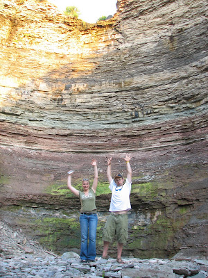
Now, to the average person when they look at the following two pictures they may say to themselves: "Wow! Not too bad. Looks interesting. It look like it is a good height but nothing all that special to write home about."
Now with the next two pictures, the same person may say to themself: "Impressive but not all that huge. It looks like those falls are about five Jon's high. Maybe 30 feet or so."
Thinking like that is the furthest thing from what it actually is. If it is at all possible - you can faintly see us at the bottom of these pictures! (You may have to click on the pictures to see the full size picture to be able to see us better!)
This area was AMAZING to say the least!!! The pictures can do all the talking really!
The apparent "landfill" at the base of the falls. There were two or three bikes, a Herby Curby, gas tank, spare tires.. just loads and loads of garbage. It was rather sad actually.
NO! Sherri is not picking her nose, she is just scratching it. (Sorry Babe!) I wanted to show this pic to kinda show the width of this bowl. You can vaguely see the trail that we took to get back to the top of these falls. No - it was not a wel defined trail and we pretty much blazed it ourselves!!! I must give credit to Sherri though - she hiked this entire trip wearing a pair of my sandals!!
Subscribe to:
Posts (Atom)